Rest, a great ferry flight, and a tall ship in the desert.
I woke Tuesday morning with one thought in my mind: a nice hearty breakfast in the lodge’s restaurant. It was a clear morning with millions of stars in the dark sky. The air was fresh and dust-free, thanks to the previous day’s rain.
My clients had spent the night camping on Hunt’s Mesa, where they probably still were, waiting for sunrise in the cold, damp, predawn light. They didn’t need me until 5:30 PM at Shiprock Airport, about 75 nautical air miles away. I’d have to fly there later in the day. There was no rush.
I made myself a cup of coffee and waited for a normal time to take the walk up to the lodge. I have the nasty habit of waking up very early every morning, no matter what time I go to bed at night. The result: I have a lot of free time in the morning when most people are still asleep. I filled it by working on my blog entries for the trip.
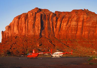
 Outside, as dawn broke, a young Navajo man stepped out of the car that had been parked next to the Long Ranger on the helipad beside mine. Turned out, he’d been hired as security for the helicopter and had spent the night in his car.
Breakfast
I brought my little laptop up to the lodge with me to check my e-mail, send captions for the Introduction figures to my editors, and post the blog entries for the first two days of the trip. All that only took about ten minutes. Then I climbed up to the restaurant. I was surprised to see that it was nearly empty — after all, it was almost 8 AM. The hostess handed me a menu and told me to sit at one of the tables by the window. I chose a table for two along the bench seat that looks out over the valley.
Immediately after seating myself, I realized that the man beside me was enormously fat. The pedestal tables are bolted into the floor — probably so they’re less likely to tip over — and the man who sat on the long bench seat simply could not fit his gut between the seat back and the table. So he sat catty-corner, with half his body in the space between his table and mine, stuffing his face with fry bread and breakfast fixings. All the while, he chatted with his wife, who was also pretty hefty. I was rather surprised by their British accents; I’d expected them to be Americans.
I had a wonderful breakfast of huevos rancheros on Navajo fry bread. It was the best meal I had at Goulding’s and enough food to hold me over for most of the day.
Meanwhile, back at the strip…
After breakfast, I walked back to the office and checked out, after making sure my key would continue to work until noon. I wasn’t planning to walk back up to the office. Then I made the long walk back down to the landing strip and my room in the hangar.
 The camera guys were out with their truck again, working on the mount they’d put on the Long Ranger. Now they had a big ball on one side that turned out to be the camera mount and camera. The pilot and his fuel guy came by for a quick chat with them before they all took off for a meeting at the nearby high school, where the rest of the film crew were gathered.
I spent most of the morning goofing off, slowing getting my stuff packed up and stowed away in the helicopter. I took a few more photos for a panoramic image I still haven’t stitched together. I also took some photos of the Valley, where low clouds hung about the buttes in the early morning light.
Ferry Flight to Shiprock and Farmington
By 11:30, I was packed up and ready to go. I left my key in the room, took a few last photos of the area, and climbed on board Zero-Mike-Lima. I was just lifting off from the pad when the pilot and crew for the Long Ranger returned.
 I flew through the northwest corner of Monument Valley, snapping a few photos along the way. These weren’t the great artistic photos my passengers had snapped during our flights. They were quick point-and-shoot images taken left-handed through the plexiglas. A way to document my trip and share images with blog readers. (I still hope to get a few low-res images from the photographers to share here.)
I made a quick pass of Goosenecks so I could snap the photo I showed on the Day Four entry for this trip. Then, spotting boats on the San Juan River, I followed the twisting canyon upriver. I was about 1/3 down into the canyon, cruising along at about 90 knots, marveling at the rock layers around me when I realized that the canyon twisted a bit more than I was willing to tackle at that speed. I could either slow down to make the sharp turns or climb and pop out of the top of the canyon. I climbed. The Canyon opened up and I was treated to a bird’s eye view of some fascinating rock uplift formations.

 The canyons leveled out and I continued following the river through relatively flat terrain. The river, which was a greenish tan color, was being fed in many places by side streams of silty runoff water from the previous day’s rain. It was interesting to see the places where the two water flows met.
I flew low over the river — sometimes as low as 150 feet. I saw wild horses in two places. There were long stretches of abandoned farm fields and empty land.
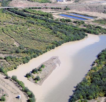
 My GPS clearly showed the intersection of four state lines. I was approaching Four Corners — the only place in the U.S. where four states meet in one place. This is a weird, arbitrary man-made tourist attraction. I flew over and saw a monument surrounded by parking surrounded by typical Navajo craft-seller shacks. I could clearly see a fee booth along the drive from the road to the monument. Yes, people were paying money to see the intersection of four state lines.
After a quick photo, I climbed out and continued on my way. A short while later, I rounded a bend and saw Shiprock rising out of the desert miles away.
Shiprock gets its name from its appearance: it looks like a tall ship — you know, the kind with sails — floating on the flat desert floor. You can see it from miles and miles away. The remains of an ancient volcano, it dominates the horizon. This is what my clients wanted to photograph at sunset and sunrise.
The river ran right to the town of Shiprock, which is about 12 miles northeast of the rock. The airstrip was south of town, 6 miles to the east of the rock. I flew over to take a look. I saw a single runway which appeared to be in decent condition and a ramp area with markings that looked as if they could be for a fire helicopter or some other emergency helicopter. There were no buildings, no planes, and no sign that the airport was regularly used by anyone. A single windsock was bright orange and in good shape.
Good Airport Management and Service
I turned to the east, toward Farmington. There was an airport there in Class Delta airspace where I could get fuel. I’d contacted one of the FBOs by phone, so they were expecting me. I listened to the ATIS recording while still 20 miles out and was surprised to hear that the airport was closed to fixed wing traffic. Turned out, they were doing runway maintenance. (At least some airport managers understand that you can keep an airport open to helicopters when runways are being worked on.) I flew between two coal-fueled power plants, made my call to the tower, and got instructions to come in from the south. A while later, I was on one of three helipads on the east end of the airport.
John from Bisti Aviation drove up in a SUV and waited for me to shut down. He brought me back to the FBO office, which was clean and comfortable (although reeked of air freshener — what is it with people?) and had WiFi. He offered me a courtesy car, which I eventually took into town for a bite to eat at the Three Rivers Brewery in historic downtown Farmington.
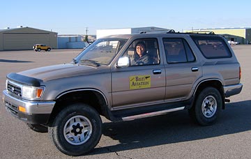
 I do need to say a bit more about this courtesy car. It was the absolute worst car I’d ever driven in my life. It was a Toyota SUV with manual transmission. I have no trouble driving a stick shift car — all three of my vehicles have manual transmission. But the clutch pedal on this one would stick to the floor. You’d put it in first gear and start moving, then go to push the clutch down to shift into second, but the pedal was already on the floor and the clutch was not engaged. I quickly learned to use the toe of my shoe to pull the pedal back up after each shift. I kept things simple by sticking to first and second gear and parking in the very first spot I found in town. On the way back, I had a bit of trouble and thought I’d actually finished off the transmission. But then I got it moving again and returned it to the FBO. It was an interesting experience — very funny but frustrating at the same time.
Back to Work
I was in the FBO office, checking e-mail and doing other online things, when Mike called. They were on their way to Shiprock. Could I meet them at the airport?
It was a bit earlier than we had planned, but I had no trouble with his request. I packed up my things and piled them neatly in a corner, out of the way. Then I got a lift out to the ramp where my helicopter was waiting, all fueled and ready to go. A while later, I was in the air, heading west toward the low-lying sun. It was about 4 PM. Sunset was at 6:51.
Four SUVs and a crowd of Russians waited for me at Shiprock’s lonely little airstrip. The wind was howling from the southeast. I set down on the ramp, cooled down the engine, and shut down. As I joined my future passengers, I wondered what the local police would think if they drove up and found a helicopter and four SUV loads of Russians on temporary visas.
We took three doors off the helicopter and loaded in the first bunch of passengers. The goal was to make three flights out to Shiprock. The first two would have to be quick to allow enough time for the third, which was for Mike and Oleg. Unfortunately, right after takeoff, my door popped open. I couldn’t get it closed while I was flying, so I had to turn around and land, close the door, and take off again. Two minutes lost.
It took four minutes to fly to the Shiprock formation from the airstrip. We then made three round-trip passes on the west side of the rock. It was my first time up close and personal with Shiprock and I was astounded by the beauty of the formation. But what really got me was the narrow ridges of lava on sandstone that radiated from the formation on three sides. The north-south ridge on the south side was the most pronounced, towering at least 100 feet off the desert floor.
We returned to Shiprock airport within 22 minutes of departure. The second flight took 20 minutes. Then Mike and Oleg, who flew for almost an hour with me. The sun was just setting when they called it quits.
I dropped them off at Shiprock’s airport. There wasn’t a soul around. The rest of their group had driven to the base of Shiprock to get some photos from the ground. We’d seen some of them along the north-south ridge. It was going to be dark soon and I didn’t want to wait for my doors. So I left them there and took off to the east, back to the lights of Farmington. The airport opened to airplane traffic at 7 PM, but there was only one on the radio as I came in. I landed at the same pad I’d had that afternoon and the Bisti Aviation SUV, this time driven by a petite young woman, drove up to meet me.
Outback and the Super 8
It was a while before Mike and Gleb returned with my doors. They were buzzed into the airport property and took a wrong turn. The FBO person and I found them as they were trying to get directions from some men working in a hangar.
 We put the doors on, stowed my luggage in their SUV, and took off in search of the Super 8 where we were staying. That’s when we discovered that Farmington was a lot bigger than we’d all thought. The motel was on the far east side of town, right next door to a Wal-Mart. Before checking in, though, we hit an Outback Steak House for a quick meal. It was after 9 PM and I kept things light.
Mike and Gleb and a few others talked about whether they’d want another flight in the morning. They spoke in Russian, so I had no clue what they were saying. I knew that their next day would take them to to someplace called the Bisti Badlands. Then I think they planned to hit Mesa Verde before heading out to the annual Balloon Festival in Albuquerque. My part of their trip was nearly over, but they had 5 days left.
My room was remarkably comfortable. I was just settling in when Mike knocked on my door. They wanted another flight. They’d meet me at 6:15 AM in the lobby. It would be just two of them: Mike and Gleb. I called the FBO, which was open 24/7, and put in a fuel order, asking her to top off the tanks sometime before 6 AM.


 The writer is sitting up front beside me, taking notes and using my Nikon D80 to shoot images of what she sees. Although a good portion of the shots have some unfortunate glare — not much you can do about that when shooting through Plexiglas — many of them are really good. Like this shot she took of a herd of wild horses we overflew on the Navajo Reservation two days ago.
 I’m treating myself to a few of the activities my excursion guests get to enjoy. For example, on Tuesday, I joined the crew for a boat ride on Lake Powell that visited the “business side” of the Glen Canyon Dam before squeezing about a mile up Antelope Canyon (see photo) and gliding up Navajo Canyon for a look at the “tapestry” of desert varnish on some cliff walls. I skipped the Sedona Jeep tour and Monument Valley tour to work with one of the video guys or just rest up. Normally, while my guest are touring, I’m scrambling to get the luggage into their hotel room and confirming reservations for the next day. You might imagine how tired I am after 6 days of playing pilot and baggage handler.
 Outside, as dawn broke, a young Navajo man stepped out of the car that had been parked next to the Long Ranger on the helipad beside mine. Turned out, he’d been hired as security for the helicopter and had spent the night in his car.
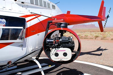 The camera guys were out with their truck again, working on the mount they’d put on the Long Ranger. Now they had a big ball on one side that turned out to be the camera mount and camera. The pilot and his fuel guy came by for a quick chat with them before they all took off for a meeting at the nearby high school, where the rest of the film crew were gathered.
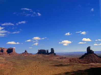 I flew through the northwest corner of Monument Valley, snapping a few photos along the way. These weren’t the great artistic photos my passengers had snapped during our flights. They were quick point-and-shoot images taken left-handed through the plexiglas. A way to document my trip and share images with blog readers. (I still hope to get a few low-res images from the photographers to share here.)
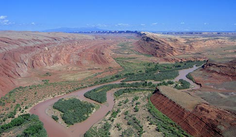
 The canyons leveled out and I continued following the river through relatively flat terrain. The river, which was a greenish tan color, was being fed in many places by side streams of silty runoff water from the previous day’s rain. It was interesting to see the places where the two water flows met.
 My GPS clearly showed the intersection of four state lines. I was approaching
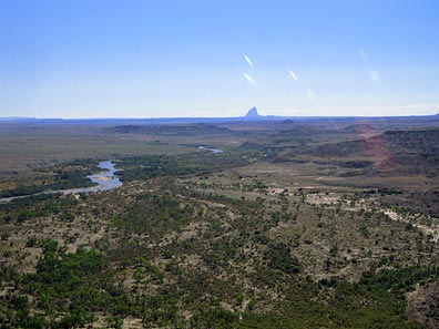
 I do need to say a bit more about this courtesy car. It was the absolute worst car I’d ever driven in my life. It was a Toyota SUV with manual transmission. I have no trouble driving a stick shift car — all three of my vehicles have manual transmission. But the clutch pedal on this one would stick to the floor. You’d put it in first gear and start moving, then go to push the clutch down to shift into second, but the pedal was already on the floor and the clutch was not engaged. I quickly learned to use the toe of my shoe to pull the pedal back up after each shift. I kept things simple by sticking to first and second gear and parking in the very first spot I found in town. On the way back, I had a bit of trouble and thought I’d actually finished off the transmission. But then I got it moving again and returned it to the FBO. It was an interesting experience — very funny but frustrating at the same time.
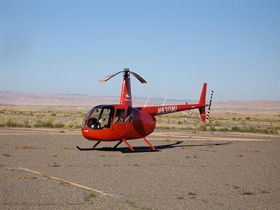 Four SUVs and a crowd of Russians waited for me at Shiprock’s lonely little airstrip. The wind was howling from the southeast. I set down on the ramp, cooled down the engine, and shut down. As I joined my future passengers, I wondered what the local police would think if they drove up and found a helicopter and four SUV loads of Russians on temporary visas.
 We put the doors on, stowed my luggage in their SUV, and took off in search of the Super 8 where we were staying. That’s when we discovered that Farmington was a lot bigger than we’d all thought. The motel was on the far east side of town, right next door to a Wal-Mart. Before checking in, though, we hit an Outback Steak House for a quick meal. It was after 9 PM and I kept things light.